
Integrated Modeling Approach to Predict the Morphodynamic Impacts of the Boğaçay Project on Konyaaltı Beach
Article Sidebar
Main Article Content
Abstract
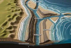
This study examines the effects of the Boğaçay Project, launched in 2017 on the Konyaaltı Coast of Antalya, on shoreline evolution using a multi-model approach. The project interrupted the natural sediment cycle, impacting both short-term morphological changes and long-term coastal stability. This study evaluates these effects through integrated models. Morphological changes from excavations at the estuary cut off natural sediment transport and were integrated with (1) the Pelnard-Considère model for long-term coastal evolution, (2) the SWAT model for basin-scale transport analysis, and (3) the XBeach model for simulating coastal hydrodynamics and morphodynamics. The study employed XBeach-based high-resolution simulations to represent physical processes, elucidate the current situation, and facilitate the testing of shoreline evolution scenarios under various engineering interventions. The model, calibrated using satellite images, coastline data, and topographic scans, showed strong agreement between numerical outputs and observations, thereby enhancing model accuracy. Results indicated an average coastal retreat of 21.7 meters over the 3 years following the project. While artificial sediment feeding slowed regression by 58%, XBeach simulations revealed that the deepened estuary worsened erosion in the east by altering wave dynamics diffraction. This integrated modeling approach highlights the critical role of sediment dynamics in coastal stability, underscoring the need for revised coastal management policies. The study identifies the spatial and temporal dynamics of shoreline changes and simulates the basic morphodynamic processes, predicting the effects of intervention scenarios. This comprehensive modeling enables the development of sustainable management strategies that protect ecosystem integrity and inform engineering solutions in human-degraded coastal systems.
Downloads
Article Details

This work is licensed under a Creative Commons Attribution-ShareAlike 4.0 International License.
Authors who publish with this journal agree to the following terms:
- Copyright of the published article belongs to the authors and grant the journal right of first publication with the work simultaneously licensed under a Creative Commons Attribution-ShareAlike 4.0 (CC BY SA) International License that allows others to share the work with an acknowledgment of the work's authorship and initial publication in this journal.
- Authors are able to enter into separate, additional contractual arrangements for the non-exclusive distribution of the journal's published version of the work (e.g., post it to an institutional repository or publish it in a book), with an acknowledgment of its initial publication in this journal.
- Authors are permitted and encouraged to post their work online (e.g., in institutional repositories or on their website) prior to and during the submission process, as it can lead to productive exchanges, as well as earlier and greater citation of published work (See the Effect of Open Access).
References
[1] E. C. F. Bird, Coastal geomorphology: an introduction. John Wiley & Sons, 2008.
[2] K. Hamon-Kerivel, A. Cooper, D. Jackson, M. Sedrati, and E. Guisado Pintado, “Shoreface mesoscale morphodynamics: A review,” Earth-Science Rev., vol. 209, p. 103330, 2020, doi: 10.1016/j.earscirev.2020.103330.
[3] P. D. Komar, “Beach processes and erosion—an introduction,” in Handbook of coastal processes and erosion, CRC Press, 2018, pp. 1–20.
[4] G. Masselink, M. Hughes, and J. Knight, “Introduction to Coastal Processes and Geomorphology,” Introd. to Coast. Process. Geomorphol., 2014, doi: 10.4324/9780203785461.
[5] A. M. Bernabeu, R. Medina, and C. Vidal, “A morphological model of the beach profile integrating wave and tidal influences,” Mar. Geol., vol. 197, no. 1–4, pp. 95–116, 2003, doi: 10.1016/S0025-3227(03)00087-2.
[6] L. D. Wright and A. D. Short, “Morphodynamic variability of surf zones and beaches: A synthesis,” Mar. Geol., vol. 56, no. 1–4, pp. 93–118, 1984, doi: 10.1016/0025-3227(84)90008-2.
[7] C. Lim and J. L. Lee, “Derivation of governing equation for short-term shoreline response due to episodic storm wave incidence: comparative verification in terms of longshore sediment transport,” Front. Mar. Sci., vol. 10, p. 1179598, 2023, doi: 10.3389/fmars.2023.1179598.
[8] J. French, A. Payo, B. Murray, J. Orford, M. Eliot, and P. Cowell, “Appropriate complexity for the prediction of coastal and estuarine geomorphic behaviour at decadal to centennial scales,” Geomorphology, vol. 256, pp. 3–16, 2016, doi: 10.1016/j.geomorph.2015.10.005.
[9] C. Lim, J. R. C. Hsu, and J. L. Lee, “MeePaSoL: A MATLAB-based GUI software tool for shoreline management,” Comput. Geosci., vol. 161, p. 105059, 2022, doi: 10.1016/j.cageo.2022.105059.
[10] M. E. Akiner and Č. Lačnjevac, “Managing Saltwater Intrusion and Agricultural Practices along the Boǧaçay River, Turkey: Effects from Excavation and Land Source Pollution,” J. Coast. Res., vol. 38, no. 3, pp. 567–577, 2022, doi: 10.2112/JCOASTRES-D-21-00101.1.
[11] E. J. Anthony, “The human influence on the Mediterranean coast over the last 200 years: A brief appraisal from a geomorphological perspective,” Landbauforschung, vol. 20, no. 3, pp. 219–226, 2014, doi: 10.4000/geomorphologie.10654.
[12] E. J. Anthony, N. Marriner, and C. Morhange, “Human influence and the changing geomorphology of Mediterranean deltas and coasts over the last 6000 years: From progradation to destruction phase?,” Earth-Science Rev., vol. 139, pp. 336–361, 2014, doi: 10.1016/j.earscirev.2014.10.003.
[13] O. E. Frihy and A. A. Khafagy, “Climate and induced changes in relation to shoreline migration trends at the Nile delta promontories, Egypt,” Catena, vol. 18, no. 2, pp. 197–211, 1991, doi: 10.1016/0341-8162(91)90017-R.
[14] M. M. El Banna and O. E. Frihy, “Human-induced changes in the geomorphology of the northeastern coast of the Nile delta, Egypt,” Geomorphology, vol. 107, no. 1–2, pp. 72–78, 2009, doi: 10.1016/j.geomorph.2007.06.025.
[15] O. Frihy and D. Lawrence, “Evolution of the modern Nile delta promontories: Development of accretional features during shoreline retreat,” Environ. Geol., vol. 46, no. 6–7, pp. 914–931, 2004, doi: 10.1007/s00254-004-1103-3.
[16] F. Sabatier, O. Samat, A. Ullmann, and S. Suanez, “Connecting large-scale coastal behaviour with coastal management of the Rhône delta,” Geomorphology, vol. 107, no. 1–2, pp. 79–89, 2009, doi: 10.1016/j.geomorph.2006.09.026.
[17] S. E. Poulos and M. B. Collins, “Fluviatile sediment fluxes to the Mediterranean Sea: A quantitative approach and the influence of dams,” Geol. Soc. Spec. Publ., vol. 191, no. 1, pp. 227–245, 2002, doi: 10.1144/GSL.SP.2002.191.01.16.
[18] J. Hooke, “Hydromorphological adjustment in meandering river systems and the role of flood events,” IAHS-AISH Publ., vol. 306, no. 306, pp. 127–135, 2006.
[19] E. J. Anthony, “Wave influence in the construction, shaping and destruction of river deltas: A review,” Mar. Geol., vol. 361, pp. 53–78, 2015, doi: 10.1016/j.margeo.2014.12.004.
[20] R. Pelnard-Considere, “Essai de theorie de l’evolution des formes de rivage en plages de sable et de galets,” Les Energies la Mer Compte Rendu Des Quatr. Journees L’hydraulique, Paris 13, 14 15 Juin 1956; Quest. III, Rapp. 1, 74-1-10, vol. 4, no. 1, pp. 289–298, 1956.
[21] P. D. Komar, “Nearshore currents and sand transport on beaches,” Elsevier Oceanogr. Ser., vol. 35, no. C, pp. 67–109, 1983, doi: 10.1016/S0422-9894(08)70500-2.
[22] J. E. Cueto, L. J. Otero Díaz, S. R. Ospino-Ortiz, and A. Torres-Freyermuth, “The role of morphodynamics in predicting coastal flooding from storms on a dissipative beach with sea level rise conditions,” Nat. Hazards Earth Syst. Sci., vol. 22, no. 3, pp. 713–728, 2022, doi: 10.5194/nhess-22-713-2022.
[23] D. Roelvink, A. Reniers, A. van Dongeren, J. van Thiel de Vries, R. McCall, and J. Lescinski, “Modelling storm impacts on beaches, dunes and barrier islands,” Coast. Eng., vol. 56, no. 11–12, pp. 1133–1152, 2009, doi: 10.1016/j.coastaleng.2009.08.006.
[24] P. W. Gassman, M. R. Reyes, C. H. Green, and J. G. Arnold, “The soil and water assessment tool: Historical development, applications, and future research directions,” Trans. ASABE, vol. 50, no. 4, pp. 1211–1250, 2007.
[25] M. S. Regasa and M. Nones, “SWAT model-based quantification of the impact of land use land cover change on sediment yield in the Fincha watershed, Ethiopia,” Front. Environ. Sci., vol. 11, p. 1146346, 2023, doi: 10.3389/fenvs.2023.1146346.
[26] S. K. Himanshu, A. Pandey, and P. Shrestha, “Application of SWAT in an Indian river basin for modeling runoff, sediment and water balance,” Environ. Earth Sci., vol. 76, no. 1, pp. 1–18, 2017, doi: 10.1007/s12665-016-6316-8.
[27] P. W. Gassman, A. M. Sadeghi, and R. Srinivasan, “Applications of the SWAT Model Special Section: Overview and Insights,” J. Environ. Qual., vol. 43, no. 1, pp. 1–8, 2014, doi: 10.2134/jeq2013.11.0466.
[28] A. G. Samaras and C. G. Koutitas, “The impact of watershed management on coastal morphology: A case study using an integrated approach and numerical modeling,” Geomorphology, vol. 211, pp. 52–63, 2014, doi: 10.1016/j.geomorph.2013.12.029.
[29] A. Luijendijk, G. Hagenaars, R. Ranasinghe, F. Baart, G. Donchyts, and S. Aarninkhof, “The state of the world’s beaches,” Sci. Rep., vol. 8, no. 1, p. 6641, 2018.
[30] J. Bamunawala et al., “A Holistic Modeling Approach to Project the Evolution of Inlet-Interrupted Coastlines Over the 21st Century,” Front. Mar. Sci., vol. 7, p. 542, 2020, doi: 10.3389/fmars.2020.00542.
[31] J. G. Arnold et al., “SWAT: Model use, calibration, and validation,” Trans. ASABE, vol. 55, no. 4, pp. 1491–1508, 2012.
[32] S. Vitousek, P. L. Barnard, P. Limber, L. Erikson, and B. Cole, “A model integrating longshore and cross-shore processes for predicting long-term shoreline response to climate change,” J. Geophys. Res. Earth Surf., vol. 122, no. 4, pp. 782–806, 2017, doi: 10.1002/2016JF004065.
[33] P. Ruggiero, M. Buijsman, G. M. Kaminsky, and G. Gelfenbaum, “Modeling the effects of wave climate and sediment supply variability on large-scale shoreline change,” Mar. Geol., vol. 273, no. 1–4, pp. 127–140, 2010, doi: 10.1016/j.margeo.2010.02.008.
[34] A. G. Samaras and C. G. Koutitas, “An integrated approach to quantify the impact of watershed management on coastal morphology,” Ocean Coast. Manag., vol. 69, pp. 68–77, 2012.
[35] ESRI, “Boğaçay River digital imaginary, satellite, and topographic map. DigitalGlobe. "GeoEye, i-cubed, USDA FSA, USGS, AEX, Getmapping, Aerogrid, IGN, IGP, Swisstopo, the GIS User Community,” 2019. https://www.arcgis.com/home/webmap/viewer.html?webmap=a7df4341d88445fd80caff34d5c4c6fc&extent=30.6138,36.8494,30.6363,36.8581 (accessed Feb. 06, 2025).
[36] Republic of Turkey Governorship of Antalya, Antalya Provincial Environmental Status Report 2018. Antalya, Turkey: Ministry of Environment and Urbanization, 2019.
[37] Republic of Turkey Governorship of Antalya, Antalya Provincial Environmental Status Report 2017. Antalya, Turkey: Ministry of Environment and Urbanization, 2018.
[38] Republic of Turkey Governorship of Antalya, Antalya Provincial Environmental Status Report 2016. Antalya, Turkey: Ministry of Environment and Urbanization, 2017.
[39] DSI (State Hydraulic Works), “2016-2018 Stream Pollution Parameters Measurements in the Boğaçay River Watershed,” Ankara, Turkey, 2019.
[40] DSI (State Hydraulic Works), “1/25000 Scale Topographic Maps and Vector Maps of the Boğaçay River Watershed area.” Ankara, Turkey., 2018.
[41] S. W. Park, S. Mostaghimi, R. A. Cooke, and P. W. McClellan, “BMP Impacts on Watershed Runoff, Sediment, and Nutrient Yields,” JAWRA J. Am. Water Resour. Assoc., vol. 30, no. 6, pp. 1011–1023, 1994, doi: 10.1111/j.1752-1688.1994.tb03349.x.
[42] Y. Yuan, S. M. Dabney, and R. L. Bingner, “Cost effectiveness of agricultural BMPs for sediment reduction in the Mississippi Delta,” J. Soil Water Conserv., vol. 57, no. 5, pp. 259–267, 2002.
[43] K. R. Merriman, P. Daggupati, R. Srinivasan, and B. Hayhurst, “Assessment of site-specific agricultural Best Management Practices in the Upper East River watershed, Wisconsin, using a field-scale SWAT model,” J. Great Lakes Res., vol. 45, no. 3, pp. 619–641, 2019, doi: 10.1016/j.jglr.2019.02.004.
[44] M. Arabi, D. W. Meals, and D. L. Hoag, “Watershed Modeling: National Institute of Food and Agriculture-Conservation Effects Assessment Project,” How to Build Better Agric. Conserv. Programs to Prot. Water Qual., pp. 84–119, 2012.
[45] M. Arabi, R. S. Govindaraju, and M. M. Hantush, “Analysis of uncertainty in evaluation of watershed management practices,” in World Environmental and Water Resources Congress 2008: Ahupua’a - Proceedings of the World Environmental and Water Resources Congress 2008, 2008, vol. 316, pp. 1–10, doi: 10.1061/40976(316)573.
[46] P. Borrelli et al., “An assessment of the global impact of 21st century land use change on soil erosion,” Nat. Commun., vol. 8, no. 1, p. 2013, 2017, doi: 10.1038/s41467-017-02142-7.
[47] Fischenich, Stability thresholds for stream restoration materials. EMRRP Technical Notes Collection (ERDC TN-EMRRP-SR-29). US Army Engineer Research and Development Center [Environmental Laboratory], 2001.
[48] R. Bhattarai and D. Dutta, “Estimation of soil erosion and sediment yield using GIS at catchment scale,” Water Resour. Manag., vol. 21, no. 10, pp. 1635–1647, 2007, doi: 10.1007/s11269-006-9118-z.
[49] N. Surian and M. Rinaldi, “Morphological response to river engineering and management in alluvial channels in Italy,” Geomorphology, vol. 50, no. 4, pp. 307–326, 2003, doi: 10.1016/S0169-555X(02)00219-2.
[50] C. Baykal, “Development of a numerical 2-dimensional beach evolution model,” Turkish J. Earth Sci., vol. 23, no. 2, pp. 215–231, 2014, doi: 10.3906/yer-1302-1.
[51] P. T. Nam, M. Larson, H. Hanson, and L. X. Hoan, “A numerical model of beach morphological evolution due to waves and currents in the vicinity of coastal structures,” Coast. Eng., vol. 58, no. 9, pp. 863–876, 2011, doi: 10.1016/j.coastaleng.2011.05.006.
[52] C. Baykal, A. Ergin, and I. Güler, “Two-Dimensional Depth-Averaged Beach Evolution Modeling: Case Study of the Kızılırmak River Mouth, Turkey,” J. Waterw. Port, Coastal, Ocean Eng., vol. 140, no. 3, p. 5014001, 2014, doi: 10.1061/(asce)ww.1943-5460.0000243.
[53] W. Zhang et al., “Numerical simulation and analysis of saltwater intrusion lengths in the pearl River Delta, China,” J. Coast. Res., vol. 29, no. 2, pp. 372–382, 2013, doi: 10.2112/JCOASTRES-D-12-00068.1.
[54] S. Shaeri, A. Etemad-Shahidi, and R. Tomlinson, “Revisiting Longshore Sediment Transport Formulas,” J. Waterw. Port, Coastal, Ocean Eng., vol. 146, no. 4, p. 4020009, 2020, doi: 10.1061/(asce)ww.1943-5460.0000557.
[55] M. Ferreira, C. Coelho, and P. A. Silva, “Littoral Drift Gradients on the Portuguese Coastal Sector Esmoriz‑Nazaré: Past and Future Trends,” Coast. Eng. Proc., no. 37, p. 22, 2023, doi: 10.9753/icce.v37.papers.22.
[56] P. Bruun, “Sea-level rise as a cause of shore erosion,” J. Waterw. Harb. Div., vol. 88, no. 1, pp. 117–130, 1962.
[57] L. G. Biolchi, S. Unguendoli, L. Bressan, B. M. S. Giambastiani, and A. Valentini, “Ensemble technique application to an XBeach-based coastal Early Warning System for the Northwest Adriatic Sea (Emilia-Romagna region, Italy),” Coast. Eng., vol. 173, p. 104081, 2022, doi: 10.1016/j.coastaleng.2022.104081.
[58] M. Villatoro et al., “An approach to assess flooding and erosion risk for open beaches in a changing climate,” Coast. Eng., vol. 87, pp. 50–76, 2014, doi: 10.1016/j.coastaleng.2013.11.009.
[59] M. Abouhalima, L. das Neves, F. Taveira-Pinto, and P. Rosa-Santos, “Machine Learning in Coastal Engineering: Applications, Challenges, and Perspectives,” J. Mar. Sci. Eng., vol. 12, no. 4, p. 638, 2024, doi: 10.3390/jmse12040638.
[60] NASA/METI, “ASTER Global Digital Elevation Model v2 [30m resolution DEM].” 2009, doi: https://doi.org/10.5067/ASTER/ASTGTM.002.
[61] T. Abreu, P. A. Silva, F. Sancho, and A. Temperville, “Analytical approximate wave form for asymmetric waves,” Coast. Eng., vol. 57, no. 7, pp. 656–667, 2010, doi: 10.1016/j.coastaleng.2010.02.005.
[62] E.U Copernicus Marine Service Information (CMEMS), “Mediterranean Sea Physics [1/8° Grid].,” 2024. https://doi.org/10.48670/moi-00016.
[63] U. and C. C. MEUCC (Ministry of Environment, “Coastal bathymetry and oceanography data of Turkey,” 2020. [Online]. Available: https://webdosya.csb.gov.tr/db/mpgm/icerikler/5.4.5-batimetri-osinagrafi-20201218095100.pdf.
[64] TSMS (Turkish State Meteorological Service), “wind forecast maps for maritime purposes.” 2023, [Online]. Available: https://www.mgm.gov.tr/mobile/denizcilik-3-gunluk-haritali.aspx.
[65] M. Arabi, J. R. Frankenberger, B. A. Engel, and J. G. Arnold, “Representation of agricultural conservation practices with SWAT,” Hydrol. Process., vol. 22, no. 16, pp. 3042–3055, 2008, doi: 10.1002/hyp.6890.
[66] A. D. Teshager, P. W. Gassman, S. Secchi, J. T. Schoof, and G. Misgna, “Modeling Agricultural Watersheds with the Soil and Water Assessment Tool (SWAT): Calibration and Validation with a Novel Procedure for Spatially Explicit HRUs,” Environ. Manage., vol. 57, no. 4, pp. 894–911, 2016, doi: 10.1007/s00267-015-0636-4.
[67] M. Samimi et al., “Modeling arid/semi-arid irrigated agricultural watersheds with SWAT: Applications, challenges, and solution strategies,” J. Hydrol., vol. 590, p. 125418, 2020, doi: 10.1016/j.jhydrol.2020.125418.
[68] E. J. Anthony and T. Aagaard, “The lower shoreface: Morphodynamics and sediment connectivity with the upper shoreface and beach,” Earth-Science Rev., vol. 210, p. 103334, 2020, doi: 10.1016/j.earscirev.2020.103334.
[69] M. J. F. Stive and H. J. de Vriend, “Modelling shoreface profile evolution,” Mar. Geol., vol. 126, no. 1–4, pp. 235–248, 1995, doi: 10.1016/0025-3227(95)00080-I.
[70] A. W. Niedoroda, C. W. Reed, D. J. P. Swift, H. Arato, and K. Hoyanagi, “Modeling shore-normal large-scale coastal evolution,” Mar. Geol., vol. 126, no. 1–4, pp. 181–199, 1995.
[71] L. C. Van Rijn, “Coastal erosion and control,” Ocean Coast. Manag., vol. 54, no. 12, pp. 867–887, 2011, doi: 10.1016/j.ocecoaman.2011.05.004.
[72] J. J. Williams, L. S. Esteves, and L. A. Rochford, “Modelling storm responses on a high-energy coastline with XBeach,” Model. Earth Syst. Environ., vol. 1, no. 1–2, pp. 1–14, 2015, doi: 10.1007/s40808-015-0003-8.
[73] A. van Dongeren, D. Roelvink, R. McCall, K. Nederhoff, and A. van Rooijen, “Modeling the Morphological Impacts of Coastal Storms,” Coast. Storms Process. Impacts, pp. 195–216, 2016, doi: 10.1002/9781118937099.ch10.
[74] R. C. Mickey, P. S. Dalyander, R. McCall, and D. Passeri, “Sensitivity of storm response to antecedent topography in the xbeach model,” J. Mar. Sci. Eng., vol. 8, no. 10, pp. 1–23, 2020, doi: 10.3390/jmse8100829.
[75] J. P. M. Syvitski, C. J. Vörösmarty, A. J. Kettner, and P. Green, “Impact of humans on the flux of terrestrial sediment to the global coastal ocean,” Science (80-. )., vol. 308, no. 5720, pp. 376–380, 2005, doi: 10.1126/science.1109454.
[76] N. C. Kraus and W. G. McDougal, “The effects of seawalls on the beach: Part I, an updated literature review,” J. Coast. Res., vol. 12, no. 3, pp. 691–701, 1996.
[77] H. Hanson and N. C. Kraus, GENESIS: generalized model for simulating shoreline change. Report 1: technical reference, vol. 89–19. US Army Engineer Waterways Experiment Station, 1989.
[78] P. D. Komar, “Beach processes and sedimentation,” 1976, doi: 10.5860/choice.36-1592.
[79] M. I. Vousdoukas, L. Mentaschi, E. Voukouvalas, A. Bianchi, F. Dottori, and L. Feyen, “Climatic and socioeconomic controls of future coastal flood risk in Europe,” Nat. Clim. Chang., vol. 8, no. 9, pp. 776–780, 2018, doi: 10.1038/s41558-018-0260-4.
[80] D. J. A. Roelvink and A. Reniers, A guide to modeling coastal morphology, vol. 12. world scientific, 2011.
[81] E. B. Goldstein, G. Coco, and N. G. Plant, “A review of machine learning applications to coastal sediment transport and morphodynamics,” Earth-Science Rev., vol. 194, pp. 97–108, 2019, doi: 10.1016/j.earscirev.2019.04.022.
[82] J. A. Roelvink, “Coastal morphodynamic evolution techniques,” Coast. Eng., vol. 53, no. 2–3, pp. 277–287, 2006.
[83] P. J. Cowell et al., “The Coastal-Tract ( Part 2 ): Applications of Aggregated Modeling of Lower-order Coastal Change,” J. Coast. Res., no. Part 2, pp. 828–848, 2003.
[84] R. J. Nicholls et al., “Coastal systems and low-lying areas,” Clim. Chang. 2007 Impacts, Adapt. Vulnerability., pp. 315–356, 2007.
[85] R. Ranasinghe, “Assessing climate change impacts on open sandy coasts: A review,” Earth-Science Rev., vol. 160, pp. 320–332, 2016, doi: 10.1016/j.earscirev.2016.07.011.