
Map-Derived Agreement Assessment of Landsat-9 OLI-2 for Island-Scale Lithological Discrimination in a Humid Tropical Setting from Langkawi Island, Malaysia
Article Sidebar
Main Article Content
Abstract
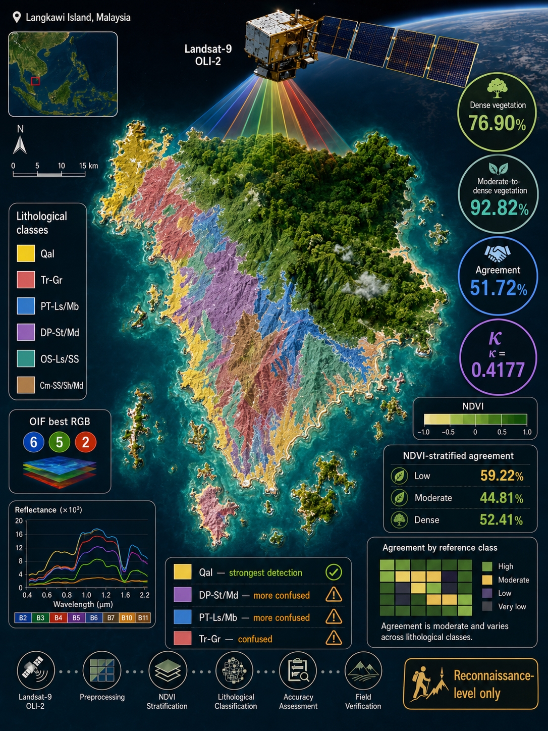
Lithological discrimination in humid tropical islands remains constrained by dense vegetation, deep weathering, regolith cover, mixed pixels, and discontinuous bedrock exposure, which collectively weaken diagnostic spectral responses. This study evaluates the capability and limitations of Landsat-9 OLI-2 for island-scale lithological discrimination in Langkawi Island, Malaysia, using an interpretable optical-only workflow. Atmospherically corrected Landsat-9 imagery was processed through false-color composites, Optimum Index Factor (OIF)-based band selection, band-ratio enhancement, Principal Component Analysis (PCA), Normalized Difference Vegetation Index (NDVI), Jeffries–Matusita separability analysis, and Maximum Likelihood Classification (MLC). The resulting MLC lithological map was assessed pixel-by-pixel against a published geological map; consequently, the reported statistics represent map-derived agreement rather than independent field-validated lithological accuracy. Results show that the OIF-selected RGB 6-5-2 composite, selected band-ratio combinations, and PCA enhanced broad contrasts among Quaternary Alluvium, granitic terrain, and carbonate-bearing formations. The MLC classification achieved an overall map-derived agreement of 51.72% and a kappa coefficient of 0.4177. Qal, Cm-SS/Sh/Md, and OS-Ls/SS showed relatively stronger agreement, whereas PT-Ls/Mb, DP-St/Md, and Tr-Gr were more affected by spectral overlap and class confusion. NDVI-stratified assessment further confirmed that vegetation cover influences classification performance, with low-vegetation areas producing higher agreement than moderate-vegetation areas. This study establishes a reproducible full-island baseline for evaluating optical multispectral lithological mapping under humid tropical conditions. These findings demonstrate that Landsat-9 OLI-2 can support reconnaissance-level lithological discrimination in humid tropical islands but remains insufficient for precise formation-level mapping without field validation and integration with SAR, DEM-derived, or higher-resolution spectral datasets.
Downloads
Article Details

This work is licensed under a Creative Commons Attribution-ShareAlike 4.0 International License.
Authors who publish with this journal agree to the following terms:
- Copyright of the published article belongs to the authors and grant the journal right of first publication with the work simultaneously licensed under a Creative Commons Attribution-ShareAlike 4.0 (CC BY SA) International License that allows others to share the work with an acknowledgment of the work's authorship and initial publication in this journal.
- Authors are able to enter into separate, additional contractual arrangements for the non-exclusive distribution of the journal's published version of the work (e.g., post it to an institutional repository or publish it in a book), with an acknowledgment of its initial publication in this journal.
- Authors are permitted and encouraged to post their work online (e.g., in institutional repositories or on their website) prior to and during the submission process, as it can lead to productive exchanges, as well as earlier and greater citation of published work (See the Effect of Open Access).
References
[1] J. M. Akhir and I. Abdullah, “Geological applications of LANDSAT thematic mapper imagery: mapping and analysis of lineaments in NW Peninsula Malaysia,” UNI. Kebangssan, Malaysia. AARS Pap. ACRS1997, Geol., 1997, [Online]. Available: https://acrs-aars.org/proceeding/ACRS1997/Papers/GEO97-1.htm
[2] N. Simon, C. Aziz Ali, K. R. Mohamed, and K. Sharir, “Best band ratio combinations for the lithological discrimination of the Dayang Bunting and Tuba Islands, Langkawi, Malaysia,” Sains Malaysiana, vol. 45, no. 5, pp. 659–667, 2016, [Online]. Available: http://journalarticle.ukm.my/9868/
[3] A. Joseph and O. Bamidele, “Application of remote sensing method for geological interpretation of Sokoto Plain, Nigeria,” South African J. Geomatics, vol. 7, no. 3, p. 360, 2019, https://doi.org/10.4314/sajg.v7i3.12
[4] S. A. Aliyan, A. S. Bratanegara, H. M. Ihsan, A. J. Astari, and L. Somantri, “Identification of Lithological Characteristics Using Multispectral Landsat 8 OLI Imagery in the Cipatujah Area, West Java, Indonesia,” in IOP Conference Series: Earth and Environmental Science, 2022, vol. 1089, no. 1, p. 12021. https://doi.org/10.1088/1755-1315/1089/1/012021
[5] L. Yan and D. P. Roy, “Using Landsat 8 and 9 operational land imager (OLI) data to characterize geometric distortion and improve geometric correction of Landsat Multispectral Scanner (MSS) imagery,” Remote Sens. Environ., vol. 321, p. 114679, 2025, https://doi.org/10.1016/j.rse.2025.114679
[6] A. B. Pour, M. Hashim, J. K. Hong, and Y. Park, “Lithological and alteration mineral mapping in poorly exposed lithologies using Landsat-8 and ASTER satellite data: North-eastern Graham Land, Antarctic Peninsula,” Ore Geol. Rev., vol. 108, pp. 112–133, 2019, https://doi.org/10.1016/j.oregeorev.2017.07.018
[7] C. Kumar, A. Shetty, S. Raval, R. Sharma, and P. K. C. Ray, “Lithological discrimination and mapping using ASTER SWIR Data in the Udaipur area of Rajasthan, India,” Procedia Earth Planet. Sci., vol. 11, pp. 180–188, 2015, https://doi.org/10.1016/j.proeps.2015.06.022
[8] R. Mohamed, J. Tamen, S. Ousmanou, F. K. Yangouo, and D. Nkouathio, “Lithological discrimination based on Landsat-9 OLI sensor and field observation data: The bana an-orogenic volcano-plutonic ring complex, West Cameroon line,” Heliyon, vol. 10, no. 17, 2024, https://doi.org/10.1016/j.heliyon.2024.e36806
[9] Y. Chen, Y. Dong, Y. Wang, F. Zhang, G. Liu, and P. Sun, “Machine learning algorithms for lithological mapping using Sentinel-2 and SRTM DEM in highly vegetated areas,” Front. Ecol. Evol., vol. 11, p. 1250971, 2023, https://doi.org/10.3389/fevo.2023.125097
[10] H. Ghrefat, A. Y. Kahal, K. Abdelrahman, H. J. Alfaifi, and S. Qaysi, “Utilization of multispectral landsat-8 remote sensing data for lithological mapping of southwestern Saudi Arabia,” J. King Saud Univ. - Sci., vol. 33, no. 4, p. 101414, 2021, https://doi.org/10.1016/j.jksus.2021.101414
[11] Z. Ourhzif, A. Algouti, A. Algouti, and F. Hadach, “Lithological mapping using landsat 8 oli and aster multispectral data in imini-ounilla district south high atlas of marrakech,” Int. Arch. Photogramm. Remote Sens. Spat. Inf. Sci. - ISPRS Arch., vol. 42, no. 2/W13, pp. 1255–1262, 2019, https://doi.org/10.5194/isprs-archives-XLII-2-W13-1255-2019
[12] A. Shebl and M. Hamdy, “Multiscale (microscopic to remote sensing) preliminary exploration of auriferous-uraniferous marbles: A case study from the Egyptian Nubian Shield,” Sci. Rep., vol. 13, no. 1, p. 9173, 2023, https://doi.org/10.1038/s41598-023-36388-7
[13] M. A. EL-Omairi and A. El Garouani, “A review on advancements in lithological mapping utilizing machine learning algorithms and remote sensing data,” Heliyon, vol. 9, no. 9, 2023, https://doi.org/10.1016/j.heliyon.2023.e20168
[14] A. Shebl et al., “Impact of DEMs for Improvement Sentinel 2 Lithological Mapping Utilizing Support Vector Machine: A Case Study of Mineralized Fe-Ti-Rich Gabbroic Rocks from the South Eastern Desert of Egypt,” Minerals, vol. 13, no. 6, p. 826, 2023, https://doi.org/10.3390/min13060826
[15] H. Bahrami, P. Esmaeili, S. Homayouni, A. B. Pour, K. Chokmani, and A. Bahroudi, “Machine Learning-Based Lithological Mapping from ASTER Remote-Sensing Imagery,” Minerals, vol. 14, no. 2, p. 202, 2024, https://doi.org/10.3390/min14020202
[16] Y. Chen, G. Liu, Z. Song, M. Li, M. Wang, and S. Wang, “Lithological Mapping in High-Vegetation Areas Using Sentinel-2, Sentinel-1, and Digital Elevation Models,” Sensors, vol. 25, no. 7, p. 2136, 2025, https://doi.org/10.3390/s25072136
[17] S. M. Ghoneim, Z. Hamimi, K. Abdelrahman, M. A. Khalifa, M. Shabban, and A. S. Abdelmaksoud, “Machine learning and remote sensing-based lithological mapping of the Duwi Shear-Belt area, Central Eastern Desert, Egypt,” Sci. Rep., vol. 14, no. 1, p. 17010, 2024, https://doi.org/10.1038/s41598-024-66199-3
[18] T. Zhang et al., “Rapid lithological mapping using multi-source remote sensing data fusion and automatic sample generation strategy,” Int. J. Digit. Earth, vol. 17, no. 1, p. 2420824, 2024, https://doi.org/10.1080/17538947.2024.2420824
[19] F. F. Sabins, “Remote sensing for mineral exploration,” Ore Geol. Rev., vol. 14, no. 3–4, pp. 157–183, 1999, https://doi.org/10.1016/S0169-1368(99)00007-4
[20] P. S. Chavez, G. L. Berlin, and L. B. Sowers, “Statistical Method for Selecting Landsat Mss Ratios.,” J. Appl. Photogr. Eng., vol. 8, no. 1, pp. 23–30, 1982.
[21] Y. Du, Y. J. Teoh, I. A. Abir, R. P. Jaya, and Y. Ulfa, “Lithological distribution using band ratio technique in Southern Langkawi, Kedah, Malaysia,” Environ. Sci. Pollut. Res., pp. 1–13, 2025, https://doi.org/10.1007/s11356-025-36465-6
[22] A. Marzouki and A. Dridri, “Lithological discrimination and structural lineaments extraction using Landsat 8 and ASTER data: a case study of Tiwit (Anti-Atlas, Morocco),” Environ. Earth Sci., vol. 82, no. 5, p. 125, 2023, https://doi.org/10.1007/s12665-023-10831-4
[23] M. Dawoud et al., “Applications of Remote Sensing in Lithological Mapping of East Gabal Atud Area, Central Eastern Desert, Egypt,” Geo-Eco-Marina, vol. 29, pp. 125–146, 2023, [Online]. Available: https://journal.geoecomar.ro/geo-eco-marina/article/view/11_2023
[24] S. Ali, H. Li, A. Ali, and J. I. Hassan, “Lithological Discrimination of Khyber Range Using Remote Sensing and Machine Learning Algorithms,” Appl. Sci., vol. 14, no. 12, p. 5064, 2024, https://doi.org/10.3390/app14125064
[25] Y. Chen, Y. Wang, F. Zhang, Y. Dong, Z. Song, and G. Liu, “Remote Sensing for Lithology Mapping in Vegetation-Covered Regions: Methods, Challenges, and Opportunities,” Minerals, vol. 13, no. 9, p. 1153, 2023, https://doi.org/10.3390/min13091153
[26] A. Shebl, M. Abdellatif, M. Hissen, M. Ibrahim Abdelaziz, and Á. Csámer, “Lithological mapping enhancement by integrating Sentinel 2 and gamma-ray data utilizing support vector machine: A case study from Egypt,” Int. J. Appl. Earth Obs. Geoinf., vol. 105, p. 102619, 2021, https://doi.org/10.1016/j.jag.2021.102619
[27] J. Xi, Q. Jiang, H. Liu, and X. Gao, “Lithological Mapping Research Based on Feature Selection Model of ReliefF-RF,” Appl. Sci., vol. 13, no. 20, p. 11225, 2023, https://doi.org/10.3390/app132011225
[28] Z. Wang and R. Zuo, “Intelligent Lithological Mapping: Challenges and Future Prospective,” Nat. Resour. Res., pp. 1–34, 2025, https://doi.org/10.1007/s11053-025-10563-1
[29] C. R. Jones, “Geology and mineral resources of Perlis, north Kedah and the Langkawi Ialands.,” Geol. Surv. Malaysia, vol. 17, p. 257, 1978, [Online]. Available: https://elib.jmg.gov.my/cgi-bin/koha/opac-detail.pl?biblionumber=33
[30] C. P. Lee, “Review of the Palaeozoic Stratigraphy of the Langkawi Islands, Malaysia,” Indones. Sedimentol. Forum Sedimentol. Comm. - Indones. Assoc. Geol., vol. 8, no. 27, pp. 5–14, 2013, https://doi.org/10.51835/bsed.2013.27.1.157
[31] L. R. M. Cocks, R. A. Fortey, and C. P. Lee, “A review of Lower and Middle Palaeozoic biostratigraphy in west peninsular Malaysia and southern Thailand in its context within the Sibumasu Terrane,” J. Asian Earth Sci., vol. 24, no. 6 SPEC. ISS., pp. 703–717, 2005, https://doi.org/10.1016/j.jseaes.2004.05.001
[32] W. F. Wan Hassan, “On some ore and skarn minerals of Langkawi,” Bull. Geol. Soc. Malaysia, vol. 46, pp. 217–221, 2003, https://doi.org/10.7186/bgsm46200336
[33] K. R. Mohamed, T. Unjah, C. A. Ali, and M. H. Kamal Roslan, “Geosite mapping of pulau ular in langkawi, Malaysia,” Sains Malaysiana, vol. 48, no. 11, pp. 2511–2519, 2019, https://doi.org/10.17576/jsm-2019-4811-21
[34] I. Metcalfe, “The Bentong–Raub Suture Zone,” J. Asian Earth Sci., vol. 18, no. 6, pp. 691–712, 2000, https://doi.org/10.1016/S1367-9120(00)00043-2
[35] T. Unjah and S. A. Halim, “Connecting legend and science through geomythology: Case of Langkawi unesco global geopark,” Kaji. Malaysia, vol. 35, pp. 77–89, 2017, https://doi.org/10.21315/KM2017.35.SUPP.1.5
[36] L. C. Rowan and J. C. Mars, “Lithologic mapping in the Mountain Pass, California area using Advanced Spaceborne Thermal Emission and Reflection Radiometer (ASTER) data,” Remote Sens. Environ., vol. 84, no. 3, pp. 350–366, 2003, https://doi.org/10.1016/S0034-4257(02)00127-X
[37] F. D. van der Meer et al., “Multi- and hyperspectral geologic remote sensing: A review,” Int. J. Appl. Earth Obs. Geoinf., vol. 14, no. 1, pp. 112–128, 2012, https://doi.org/10.1016/j.jag.2011.08.002
[38] Y. Ninomiya, B. Fu, and T. J. Cudahy, “Detecting lithology with Advanced Spaceborne Thermal Emission and Reflection Radiometer (ASTER) multispectral thermal infrared ‘radiance-at-sensor’ data,” Remote Sens. Environ., vol. 99, no. 1–2, pp. 127–139, 2005, https://doi.org/10.1016/j.rse.2005.06.009
[39] A. B. Pour and M. Hashim, “Hydrothermal alteration mapping from Landsat-8 data, Sar Cheshmeh copper mining district, south-eastern Islamic Republic of Iran,” J. Taibah Univ. Sci., vol. 9, no. 2, pp. 155–166, 2015, https://doi.org/10.1016/j.jtusci.2014.11.008
[40] M. Sekandari et al., “Application of Landsat-8, Sentinel-2, ASTER and Worldview-3 spectral imagery for exploration of carbonate-hosted Pb-Zn deposits in the Central Iranian Terrane (CIT),” Remote Sens., vol. 12, no. 8, p. 1239, 2020, https://doi.org/10.3390/RS12081239
[41] G. Chander, B. L. Markham, and D. L. Helder, “Summary of current radiometric calibration coefficients for Landsat MSS, TM, ETM+, and EO-1 ALI sensors,” Remote Sens. Environ., vol. 113, no. 5, pp. 893–903, 2009, https://doi.org/10.1016/j.rse.2009.01.007
[42] K. W. Abdelmalik, “Landsat 8: Utilizing sensitive response bands concept for image processing and mapping of basalts,” Egypt. J. Remote Sens. Sp. Sci., vol. 23, no. 3, pp. 263–274, 2020, https://doi.org/10.1016/j.ejrs.2019.04.004
[43] C. J. Tucker, “Red and photographic infrared linear combinations for monitoring vegetation,” Remote Sens. Environ., vol. 8, no. 2, pp. 127–150, 1979, https://doi.org/10.1016/0034-4257(79)90013-0
[44] S. A. Drury, “Image interpretation in geology,” Geocarto Int., vol. 2, no. 2, p. 48, 1987, https://doi.org/10.1080/10106048709354098
[45] E. A. Ali, “Landsat ETM+7 Digital Image Processing Techniques for Lithological and Structural Lineament Enhancement: Case Study Around Abidiya Area, Sudan,” Open Remote Sens. J., vol. 5, no. 1, pp. 83–89, 2012, https://doi.org/10.2174/1875413901205010083
[46] A. Julzarika, N. Anggraini, and S. W. Adawiah, “Detection of True Mangroves in Indonesia Using Satellite Remote Sensing,” J. Environ. Anal. Prog., pp. 157–167, 2019, https://doi.org/10.24221/jeap.4.3.2019.2488.157-167
[47] F. Masoumi, T. Eslamkish, A. A. Abkar, M. Honarmand, and J. R. Harris, “Integration of spectral, thermal, and textural features of ASTER data using Random Forests classification for lithological mapping,” J. African Earth Sci., vol. 129, pp. 445–457, 2017, https://doi.org/10.1016/j.jafrearsci.2017.01.028
[48] Z. Adiri, A. El Harti, A. Jellouli, L. Maacha, and E. M. Bachaoui, “Lithological mapping using multispectral ASTER and Landsat 8 data in the Bas Drâa inlier, Moroccan Anti Atlas,” Earth Resour. Environ. Remote Sensing/GIS Appl. VI, vol. 9644, no. 1, p. 96440L, 2015, https://doi.org/10.1117/12.2193775
[49] B. Munkhsuren, B. Enkhdalai, T. Narantsetseg, K. Udaanjargal, D. Orolmaa, and D. Munkhjin, “Lithological mapping using remote sensing techniques: A case study of Alagbayan area, Dornogobi province, Mongolia,” Mong. Geosci., vol. 26, no. 53, pp. 37–54, 2021, https://doi.org/10.5564/mgs.v26i53.1790
[50] T. M. Lillesand and R. W. Kiefer, Remote sensing and image interpretation. John Wiley & Sons, 1979. https://doi.org/10.2307/634969
[51] J. A. Richards, Remote sensing digital image analysis: An introduction, vol. 9783642300. Springer, 2013. https://doi.org/10.1007/978-3-642-30062-2
[52] I. Bentahar and M. Raji, “Comparison of Landsat OLI, ASTER, and Sentinel 2A data in lithological mapping: A Case study of Rich area (Central High Atlas, Morocco),” Adv. Sp. Res., vol. 67, no. 3, pp. 945–963, 2021, https://doi.org/10.1016/j.asr.2020.10.037
[53] R. G. Congalton and K. Green, Assessing the accuracy of remotely sensed data: Principles and practices, second edition. CRC press, 2008.
[54] K. Kulkarni and P. A. Vijaya, “Separability analysis of the band combinations for land cover classification of satellite images,” Int. J. Eng. Trends Technol., vol. 69, no. 8, pp. 138–144, 2021, https://doi.org/10.14445/22315381/IJETT-V69I8P217
[55] A. Laake, “Integration of Satellite Imagery, Geology and Geophysical Data,” Earth Environ. Sci., pp. 467–492, 2011, https://doi.org/10.5772/27613
[56] M. K. Tripathi, H. Govil, and P. Diwan, “Lithological mapping using digital image processing techniques on landsat 8 OLI remote sensing data in Jahajpur, Bhilwara, Rajasthan,” in 2019 2nd International Conference on Intelligent Communication and Computational Techniques, ICCT 2019, 2019, pp. 43–48. https://doi.org/10.1109/ICCT46177.2019.8969043
[57] Y. Lu, C. Yang, and L. Han, “Mapping bedrock with vegetation spectral features using time series Sentinel-2 images,” Geocarto Int., vol. 38, no. 1, p. 2236574, 2023, https://doi.org/10.1080/10106049.2023.2236574
[58] M. A. El-Omairi and A. El Garouani, “Lithological Mapping using Artificial Intelligence and Remote Sensing data: A Case Study of Bab Boudir region, Morocco,” in BIO Web of Conferences, 2024, vol. 115, p. 1005. https://doi.org/10.1051/bioconf/202411501005