
Reconstructing and Projecting Urban Expansion in Makassar Using Integrated ANN–CA and Bayesian Weights of Evidence, 2005–2035
Article Sidebar
Main Article Content
Abstract
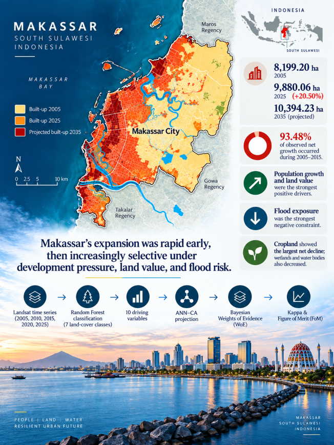
Coastal urbanization requires spatial models that distinguish historical change from conditional projections. This study reconstructed land-use and land-cover dynamics in Makassar, Indonesia, from 2005 to 2025 and projected built-up expansion to 2035 using an integrated artificial neural network–cellular automata (ANN–CA) framework and Bayesian Weights of Evidence (WoE). Five Landsat-derived maps were classified into seven classes using Random Forest, with reported overall accuracy ranging from 62.83% to 87.61%. Ten demographic, accessibility, economic, topographic, and environmental variables were used to estimate transition potential and interpret factor-class associations. Model performance was evaluated using Kappa and the Figure of Merit. Built-up land increased from 8,199.20 ha in 2005 to 9,880.06 ha in 2025, a net gain of 1,680.86 ha (20.50%), while its share of the study area rose from 46.61% to 56.17%. Expansion decelerated sharply: 93.48% of the observed net increase occurred during 2005–2015. Cropland recorded the largest net decline (861.81 ha), whereas wetlands and water bodies jointly declined by 607.87 ha. Population growth and land value showed the strongest positive summarized contrasts, while the flood-exposure variable showed the strongest negative contrast. Kappa reached 0.768, but the Figure of Merit was 21.01%, indicating stronger whole-map agreement than locational accuracy for changed cells. Built-up land is projected to reach 10,394.23 ha (59.09% of the study area) by 2035, with 93.38% of projected growth occurring after 2030. The results provide a conditional basis for spatial screening of development pressure, but mapping uncertainty, uneven temporal allocation, and limited locational accuracy require cautious planning interpretation.
Downloads
Article Details

This work is licensed under a Creative Commons Attribution-ShareAlike 4.0 International License.
Authors who publish with this journal agree to the following terms:
- Copyright of the published article belongs to the authors and grant the journal right of first publication with the work simultaneously licensed under a Creative Commons Attribution-ShareAlike 4.0 (CC BY SA) International License that allows others to share the work with an acknowledgment of the work's authorship and initial publication in this journal.
- Authors are able to enter into separate, additional contractual arrangements for the non-exclusive distribution of the journal's published version of the work (e.g., post it to an institutional repository or publish it in a book), with an acknowledgment of its initial publication in this journal.
- Authors are permitted and encouraged to post their work online (e.g., in institutional repositories or on their website) prior to and during the submission process, as it can lead to productive exchanges, as well as earlier and greater citation of published work (See the Effect of Open Access).
References
[1] S. Angel, “Urban expansion: theory, evidence and practice,” Build. Cities, vol. 4, no. 1, pp. 124–138, 2023, https://doi.org/10.5334/bc.348
[2] J. de Abreu e Silva and M. Correia, “The main drivers of urban sprawl in Portuguese medium cities between 2001 and 2011,” Land use policy, vol. 132, p. 106803, 2023, https://doi.org/10.1016/j.landusepol.2023.106803
[3] X. Liu et al., “High-spatiotemporal-resolution mapping of global urban change from 1985 to 2015,” Nat. Sustain., vol. 3, no. 7, pp. 564–570, 2020, https://doi.org/10.1038/s41893-020-0521-x
[4] R. Mahtta et al., “Urban land expansion: the role of population and economic growth for 300+ cities,” npj Urban Sustain., vol. 2, no. 1, p. 5, 2022, https://doi.org/10.1038/s42949-022-00048-y
[5] K. C. Seto, M. Fragkias, B. Güneralp, and M. K. Reilly, “A meta-analysis of global urban land expansion,” PLoS One, vol. 6, no. 8, p. e23777, 2011, https://doi.org/10.1371/journal.pone.0023777
[6] J. van Vliet, “Direct and indirect loss of natural area from urban expansion,” Nat. Sustain., vol. 2, no. 8, pp. 755–763, 2019, https://doi.org/10.1038/s41893-019-0340-0
[7] K. C. Seto, B. Güneralp, and L. R. Hutyra, “Global forecasts of urban expansion to 2030 and direct impacts on biodiversity and carbon pools,” Proc. Natl. Acad. Sci. U. S. A., vol. 109, no. 40, pp. 16083–16088, 2012, https://doi.org/10.1073/pnas.1211658109
[8] X. Liu, X. Li, Y. Chen, Z. Tan, S. Li, and B. Ai, “A new landscape index for quantifying urban expansion using multi-temporal remotely sensed data,” Landsc. Ecol., vol. 25, no. 5, pp. 671–682, 2010, https://doi.org/10.1007/s10980-010-9454-5
[9] M. A. Wulder et al., “Current status of Landsat program, science, and applications,” Remote Sens. Environ., vol. 225, pp. 127–147, 2019, https://doi.org/10.1016/j.rse.2019.02.015
[10] T. R. Loveland and J. R. Irons, “Landsat 8: The plans, the reality, and the legacy,” Remote Sens. Environ., vol. 185, pp. 1–6, 2016. https://doi.org/10.1016/j.rse.2016.07.033
[11] X. Li and A. G. O. Yeh, “Neural-network-based cellular automata for simulating multiple land use changes using GIS,” Int. J. Geogr. Inf. Sci., vol. 16, no. 4, pp. 323–343, 2002, https://doi.org/10.1080/13658810210137004
[12] L. Poelmans and A. Van Rompaey, “Detecting and modelling spatial patterns of urban sprawl in highly fragmented areas: A case study in the Flanders-Brussels region,” Landsc. Urban Plan., vol. 93, no. 1, pp. 10–19, 2009, https://doi.org/10.1016/j.landurbplan.2009.05.018
[13] T. Basu, A. Das, and P. Pereira, “Exploring the drivers of urban expansion in a medium-class urban agglomeration in India using the remote sensing techniques and geographically weighted models,” Geogr. Sustain., vol. 4, no. 2, pp. 150–160, 2023, https://doi.org/10.1016/j.geosus.2023.03.002
[14] D. R. Capozza and R. W. Helsley, “The fundamentals of land prices and urban growth,” J. Urban Econ., vol. 26, no. 3, pp. 295–306, 1989, https://doi.org/10.1016/0094-1190(89)90003-X
[15] A. Sarkar and P. Chouhan, “Modeling spatial determinants of urban expansion of Siliguri a metropolitan city of India using logistic regression,” Model. Earth Syst. Environ., vol. 6, no. 4, pp. 2317–2331, 2020, https://doi.org/10.1007/s40808-020-00815-9
[16] B. Güneralp, I. Güneralp, and Y. Liu, “Changing global patterns of urban exposure to flood and drought hazards,” Glob. Environ. Chang., vol. 31, pp. 217–225, 2015, https://doi.org/10.1016/j.gloenvcha.2015.01.002
[17] K. M. Andreadis, O. E. J. Wing, E. Colven, C. J. Gleason, P. D. Bates, and C. M. Brown, “Urbanizing the floodplain: global changes of imperviousness in flood-prone areas,” Environ. Res. Lett., vol. 17, no. 10, pp. 1–9, 2022, https://doi.org/10.1088/1748-9326/ac9197
[18] A. A. Kadhim, M. R. Aya, and Z. N. Jasim, “Flood Prone Areas Mapping Using Remote Sensing and GIS Techniques in Kalal Badrah Basin, Wasit, East of Iraq,” J. Appl. Eng. Technol. Sci., vol. 7, no. 2, pp. 1550–1560, 2026, https://doi.org/10.37385/jaets.v7i2.9476
[19] M. H. Saputra and H. S. Lee, “Prediction of land use and land cover changes for North Sumatra, Indonesia, using an artificial-neural-network-based cellular automaton,” Sustain., vol. 11, no. 11, p. 3024, 2019, https://doi.org/10.3390/su11113024
[20] T. Xu, D. Zhou, and Y. Li, “Integrating ANNs and Cellular Automata–Markov Chain to Simulate Urban Expansion with Annual Land Use Data,” Land, vol. 11, no. 7, p. 1074, 2022, https://doi.org/10.3390/land11071074
[21] G. F. Bonham-Carter, Geographic Information Systems for Geoscientists. Oxford: Pergamon, 1994. https://doi.org/10.1016/c2013-0-03864-9
[22] H. Shafizadeh-Moghadam, A. Tayyebi, and M. Helbich, “Transition index maps for urban growth simulation: application of artificial neural networks, weight of evidence and fuzzy multi-criteria evaluation,” Environ. Monit. Assess., vol. 189, no. 6, p. 300, 2017, https://doi.org/10.1007/s10661-017-5986-3
[23] H. Shafizadeh-Moghadam, M. Minaei, R. G. Pontius, A. Asghari, and H. Dadashpoor, “Integrating a Forward Feature Selection algorithm, Random Forest, and Cellular Automata to extrapolate urban growth in the Tehran-Karaj Region of Iran,” Comput. Environ. Urban Syst., vol. 87, p. 101595, 2021, https://doi.org/10.1016/j.compenvurbsys.2021.101595
[24] R. G. Pontius and M. Millones, “Death to Kappa: Birth of quantity disagreement and allocation disagreement for accuracy assessment,” Int. J. Remote Sens., vol. 32, no. 15, pp. 4407–4429, 2011, https://doi.org/10.1080/01431161.2011.552923
[25] R. G. Pontius et al., “Comparing the input, output, and validation maps for several models of land change,” Ann. Reg. Sci., vol. 42, no. 1, pp. 11–37, 2008, https://doi.org/10.1007/s00168-007-0138-2
[26] M. R. Abidin, R. Nur, E. M. Mayzarah, and R. Umar, “Estimating and Monitoring the Land Surface Temperature (LST) Using Landsat OLI 8 TIRS,” Int. J. Environ. Eng. Educ., vol. 3, no. 1, pp. 17–24, 2021, https://doi.org/10.55151/ijeedu.v3i1.43
[27] M. I. Ali, G. D. Dirawan, A. H. Hasim, and M. R. Abidin, “Detection of changes in surface water bodies urban area with NDWI and MNDWI methods,” International Journal on Advanced Science, Engineering and Information Technology, vol. 9, no. 3. pp. 946–951, 2019. https://doi.org/10.18517/ijaseit.9.3.8692
[28] T. Arifin et al., “Forecasting land-use changes due to coastal city development on the peri-urban area in Makassar City, Indonesia,” Egypt. J. Remote Sens. Sp. Sci., vol. 26, no. 1, pp. 197–206, 2023, https://doi.org/10.1016/j.ejrs.2023.02.002
[29] E. E. Ramsay et al., “Spatio-temporal development of the urban heat island in a socioeconomically diverse tropical city,” Environ. Pollut., vol. 316, p. 120443, 2023, https://doi.org/10.1016/j.envpol.2022.120443
[30] S. Wulandari, F. Pratama, N. Andika, P. Wongso, W. Wijayasari, and F. I. W. Rohmat, “Identifying dominant river contributions to urban flooding: a scenario-based study of Makassar City,” Front. Built Environ., vol. 11, p. 1612416, 2025, https://doi.org/10.3389/fbuil.2025.1612416
[31] M. I. J. Putra and S. Phinn, “Integrating artificial neural network-cellular automata and bayesian weight of evidence for spatiotemporal analysis of urban change in Brisbane City,” Comput. Urban Sci., vol. 6, no. 1, p. 13, 2026, https://doi.org/10.1007/s43762-026-00248-7
[32] R. M. Rosati, “Urban Sprawl and Routing: A Comparative Study on 156 European Cities,” Landsc. Urban Plan., vol. 253, p. 105205, 2025, https://doi.org/10.1016/j.landurbplan.2024.105205
[33] L. N. Tellier, “Characterizing urban form by means of the Urban Metric System,” Land use policy, vol. 111, p. 104672, 2021, https://doi.org/10.1016/j.landusepol.2020.104672
[34] S. Martinuzzi, W. A. Gould, and O. M. Ramos González, “Land development, land use, and urban sprawl in Puerto Rico integrating remote sensing and population census data,” Landsc. Urban Plan., vol. 79, no. 3–4, pp. 288–297, 2007, https://doi.org/10.1016/j.landurbplan.2006.02.014
[35] A. El Garouani, D. J. Mulla, S. El Garouani, and J. Knight, “Analysis of urban growth and sprawl from remote sensing data: Case of Fez, Morocco,” Int. J. Sustain. Built Environ., vol. 6, no. 1, pp. 160–169, 2017, https://doi.org/10.1016/j.ijsbe.2017.02.003
[36] S. Gaur, A. Mittal, A. Bandyopadhyay, I. Holman, and R. Singh, “Spatio-temporal analysis of land use and land cover change: a systematic model inter-comparison driven by integrated modelling techniques,” Int. J. Remote Sens., vol. 41, no. 23, pp. 9229–9255, 2020, https://doi.org/10.1080/01431161.2020.1815890
[37] C. Wang et al., “Spatial-temporal patterns of urban expansion by land use/ land cover transfer in China,” Ecol. Indic., vol. 155, p. 111009, 2023, https://doi.org/10.1016/j.ecolind.2023.111009
[38] R. Antonio Chaparro Torres, J. Wang, J. Zhang, L. Liu, and Y. Lan, “Temporal analysis of land degradation and urban expansion in central Yunnan Province using remote sensing for supporting sustainable development goals 11/15,” Ecol. Indic., vol. 163, p. 112058, 2024, https://doi.org/10.1016/j.ecolind.2024.112058
[39] S. M. Sithole, W. Musakwa, J. Magidi, and A. Y. Kibangou, “Characterising landcover changes and urban sprawl using geospatial techniques and landscape metrics in Bulawayo, Zimbabwe (1984–2022),” Heliyon, vol. 10, no. 6, 2024, https://doi.org/10.1016/j.heliyon.2024.e27275
[40] M. R. Abidin and A. Arfan, “Detection of Development and Density Urban Build-Up Area with Satellite Image Overlay,” Int. J. Environ. Eng. Educ., vol. 1, no. 2, pp. 40–45, 2019, https://doi.org/10.55151/ijeedu.v1i2.12
[41] S. Fazal, “The need for preserving farmland. A case study from a predominantly agrarian economy (India),” Landsc. Urban Plan., vol. 55, no. 1, pp. 1–13, 2001, https://doi.org/10.1016/S0169-2046(00)00134-1
[42] W. Song and X. Deng, “Land-use/land-cover change and ecosystem service provision in China,” Sci. Total Environ., vol. 576, pp. 705–719, 2017, https://doi.org/10.1016/j.scitotenv.2016.07.078
[43] I. A. Festus, I. F. Omoboye, and O. B. Andrew, “Urban Sprawl: Environmental Consequence of Rapid Urban Expansion,” Malaysian J. Soc. Sci. Humanit., vol. 5, no. 6, pp. 110–118, 2020, https://doi.org/10.47405/mjssh.v5i6.411
[44] B. F. Frimpong, A. Koranteng, and F. S. Opoku, “Analysis of urban expansion and its impact on temperature utilising remote sensing and GIS techniques in the Accra Metropolis in Ghana (1986–2022),” SN Appl. Sci., vol. 5, no. 8, p. 225, 2023, https://doi.org/10.1007/s42452-023-05439-z
[45] G. L. Vasárus, J. Z. Farkas, E. Hoyk, and A. D. Kovács, “The impact of urban sprawl on the urban-rural fringe of post-socialist cities in Central and Eastern Europe – Case study from Hungary,” J. Urban Manag., vol. 13, no. 4, pp. 800–812, 2024, https://doi.org/10.1016/j.jum.2024.06.006
[46] M. Arvin, M. Jalaei, J. Taheri, B. Badakhshan, M. Ghane, and A. Sharifi, “Examining the relationship between urban form and social inequality: A neighborhood-level analysis,” Appl. Geogr., vol. 176, p. 103532, 2025, https://doi.org/10.1016/j.apgeog.2025.103532
[47] S. Mansour, E. Ghoneim, A. El-Kersh, S. Said, and S. Abdelnaby, “Spatiotemporal Monitoring of Urban Sprawl in a Coastal City Using GIS-Based Markov Chain and Artificial Neural Network (ANN),” Remote Sens., vol. 15, no. 3, p. 601, 2023, https://doi.org/10.3390/rs15030601
[48] A. D. Sakti et al., “Machine learning based urban sprawl assessment using integrated multi-hazard and environmental-economic impact,” Sci. Rep., vol. 14, no. 1, p. 13385, 2024, https://doi.org/10.1038/s41598-024-62001-6
[49] K. Ghasemi, A. M. Jarallah Al-Zubaidi, M. M. Qelichi, and K. Dolatkhahi, “Understanding urban sprawl in Baqubah, Iraq: A study of influential factors,” J. Urban Manag., vol. 14, no. 3, pp. 787–812, 2025, https://doi.org/10.1016/j.jum.2025.01.013
[50] K. M. Almatar and M. F. Alhajri, “Drivers of urban sprawl in Dammam metropolitan area (DMA), Kingdom of Saudi Arabia: A qualitative exploration,” J. Urban Manag., vol. 13, no. 3, pp. 469–481, 2024, https://doi.org/10.1016/j.jum.2024.06.003
[51] L. Congedo and S. Macchi, “The demographic dimension of climate change vulnerability: Exploring the relation between population growth and urban sprawl in Dar es Salaam,” Curr. Opin. Environ. Sustain., vol. 13, pp. 1–10, 2015, https://doi.org/10.1016/j.cosust.2014.12.002
[52] H. Talkhabi, K. J. Ghalehteimouri, M. S. Mehranjani, A. Zanganeh, and T. Karami, “Spatial and temporal population change in the Tehran Metropolitan Region and its consequences on urban decline and sprawl,” Ecol. Inform., vol. 70, p. 101731, 2022, https://doi.org/10.1016/j.ecoinf.2022.101731
[53] N. M. Sari, D. Kushardono, Mukhoriyah, Kustiyo, and M. D. M. Manessa, “an Optimized Artificial Neural Network for the Classification of Urban Environment Comfort Using Landsat-8 Remote Sensing Data in Greater Jakarta Area, Indonesia,” J. Appl. Eng. Technol. Sci., vol. 4, no. 2, pp. 743–755, 2023, https://doi.org/10.37385/jaets.v4i2.1760
[54] Z. Wang, Q. Han, and B. de Vries, “Land Use/Land Cover and Accessibility: Implications of the Correlations for Land Use and Transport Planning,” Appl. Spat. Anal. Policy, vol. 12, no. 4, pp. 923–940, 2019, https://doi.org/10.1007/s12061-018-9278-2
[55] Y. Liu, X. Cao, J. Xu, and T. Li, “Influence of traffic accessibility on land use based on Landsat imagery and internet map: A case study of the Pearl River Delta urban agglomeration,” PLoS One, vol. 14, no. 12, p. e0224136, 2019, https://doi.org/10.1371/journal.pone.0224136
[56] D. Kasraian, K. Maat, D. Stead, and B. van Wee, “Long-term impacts of transport infrastructure networks on land-use change: an international review of empirical studies,” Transp. Rev., vol. 36, no. 6, pp. 772–792, 2016, https://doi.org/10.1080/01441647.2016.1168887
[57] B. Rimal, H. Keshtkar, R. Sharma, N. Stork, S. Rijal, and R. Kunwar, “Simulating urban expansion in a rapidly changing landscape in eastern Tarai, Nepal,” Environ. Monit. Assess., vol. 191, no. 4, p. 255, 2019, https://doi.org/10.1007/s10661-019-7389-0
[58] A. P. Pratama, M. H. Yudhistira, and E. Koomen, “Highway expansion and urban sprawl in the Jakarta Metropolitan Area,” Land use policy, vol. 112, p. 105856, 2022, https://doi.org/10.1016/j.landusepol.2021.105856
[59] X. Zhu, T. Qian, and Y. Wei, “Do high-speed railways accelerate urban land expansion in China? A study based on the multi-stage difference-in-differences model,” Socioecon. Plann. Sci., vol. 71, p. 100846, 2020, https://doi.org/10.1016/j.seps.2020.100846
[60] M. Aïkous, J. Dubé, C. Brunelle, and M. P. Champagne, “Is highway expansion and impacts on land use changes: An event study approach,” Transp. Res. Part D Transp. Environ., vol. 119, p. 103730, 2023, https://doi.org/10.1016/j.trd.2023.103730
[61] M. Iacono and D. Levinson, “Mutual causality in road network growth and economic development,” Transp. Policy, vol. 45, pp. 209–217, 2016, https://doi.org/10.1016/j.tranpol.2015.06.005
[62] J. Zhu, X. Niu, and Y. Wang, “Polycentric Urban Spatial Structure Identification Based on Morphological and Functional Dimensions: Evidence from Three Chinese Cities,” Sustain. , vol. 16, no. 6, p. 2584, 2024, https://doi.org/10.3390/su16062584
[63] F. Hao, M. Lu, T. Yu, and S. Wang, “Identification and characterization of urban polycentric structure based on points of interest in Shenyang, China,” Growth Change, vol. 55, no. 1, p. e12697, 2024, https://doi.org/10.1111/grow.12697
[64] H. Yu, S. Zhu, J. V. Li, and L. Wang, “Dynamics of urban sprawl: Deciphering the role of land prices and transportation costs in government-led urbanization,” J. Urban Manag., vol. 13, no. 4, pp. 736–754, 2024, https://doi.org/10.1016/j.jum.2024.08.002
[65] X. Liang, X. Liu, X. Li, Y. Chen, H. Tian, and Y. Yao, “Delineating multi-scenario urban growth boundaries with a CA-based FLUS model and morphological method,” Landsc. Urban Plan., vol. 177, pp. 47–63, 2018, https://doi.org/10.1016/j.landurbplan.2018.04.016
[66] Y. Li, J. Li, and J. Chu, “Research on land-use evolution and ecosystem services value response in mountainous counties based on the SD-PLUS model,” Ecol. Evol., vol. 12, no. 10, p. e9431, 2022, https://doi.org/10.1002/ece3.9431
[67] C. M. Viana and J. Rocha, “Evaluating dominant land use/land cover changes and predicting future scenario in a rural region using a memoryless stochastic method,” Sustain., vol. 12, no. 10, p. 4332, 2020, https://doi.org/10.3390/su12104332
[68] K. Jafarpour Ghalehteimouri, A. Shamsoddini, M. N. Mousavi, F. Binti Che Ros, and A. Khedmatzadeh, “Predicting spatial and decadal of land use and land cover change using integrated cellular automata Markov chain model based scenarios (2019–2049) Zarriné-Rūd River Basin in Iran,” Environ. Challenges, vol. 6, p. 100399, 2022, https://doi.org/10.1016/j.envc.2021.100399
[69] N. R. Khwarahm, S. Qader, K. Ararat, and A. M. Fadhil Al-Quraishi, “Predicting and mapping land cover/land use changes in Erbil /Iraq using CA-Markov synergy model,” Earth Sci. Informatics, vol. 14, no. 1, pp. 393–406, 2021, https://doi.org/10.1007/s12145-020-00541-x
[70] A. E. Al-Dousari, A. Mishra, and S. Singh, “Land use land cover change detection and urban sprawl prediction for Kuwait metropolitan region, using multi-layer perceptron neural networks (MLPNN),” Egypt. J. Remote Sens. Sp. Sci., vol. 26, no. 2, pp. 381–392, 2023, https://doi.org/10.1016/j.ejrs.2023.05.003
[71] W. Yue, C. Qin, M. Su, Y. Teng, and C. Xu, “Simulation and prediction of land use change in Dongguan of China based on ANN cellular automata - Markov chain model,” Environ. Sustain. Indic., vol. 22, p. 100355, 2024, https://doi.org/10.1016/j.indic.2024.100355
[72] H. He and E. A. Garcia, “Learning from Imbalanced Data,” IEEE Trans. Knowl. Data Eng., vol. 21, no. 9, pp. 1263–1284, 2009, https://doi.org/10.1109/TKDE.2008.239
[73] Y. Zhou, C. Huang, T. Wu, and M. Zhang, “A novel spatio-temporal cellular automata model coupling partitioning with CNN-LSTM to urban land change simulation,” Ecol. Modell., vol. 482, p. 110394, 2023, https://doi.org/10.1016/j.ecolmodel.2023.110394
[74] G. Shmueli, “To explain or to predict?,” Stat. Sci., vol. 25, no. 3, pp. 289–310, 2010, https://doi.org/10.1214/10-STS330
[75] S. Abdullahi and B. Pradhan, “Land use change modeling and the effect of compact city paradigms: integration of GIS-based cellular automata and weights-of-evidence techniques,” Environ. Earth Sci., vol. 77, no. 6, art. 251, 2018, https://doi.org/10.1007/s12665-018-7429-z
[76] Y. Feng, R. Wang, X. Tong, and H. Shafizadeh-Moghadam, “How much can temporally stationary factors explain cellular automata-based simulations of past and future urban growth?,” Comput. Environ. Urban Syst., vol. 76, pp. 150–162, 2019, https://doi.org/10.1016/j.compenvurbsys.2019.04.010
[77] D. Lü, G. Gao, Y. Lü, Y. Ren, and B. Fu, “An effective accuracy assessment indicator for credible land use change modelling: Insights from hypothetical and real landscape analyses,” Ecol. Indic., vol. 117, p. 106552, 2020, https://doi.org/10.1016/j.ecolind.2020.106552
[78] J. van Vliet, A. K. Bregt, and A. Hagen-Zanker, “Revisiting Kappa to account for change in the accuracy assessment of land-use change models,” Ecol. Modell., vol. 222, no. 8, pp. 1367–1375, 2011, https://doi.org/10.1016/j.ecolmodel.2011.01.017
[79] X. Liu et al., “A future land use simulation model (FLUS) for simulating multiple land use scenarios by coupling human and natural effects,” Landsc. Urban Plan., vol. 168, pp. 94–116, 2017, https://doi.org/10.1016/j.landurbplan.2017.09.019
[80] O. G. Varga, R. G. Pontius, S. K. Singh, and S. Szabó, “Intensity Analysis and the Figure of Merit’s components for assessment of a Cellular Automata – Markov simulation model,” Ecol. Indic., vol. 101, pp. 933–942, 2019, https://doi.org/10.1016/j.ecolind.2019.01.057
[81] M. I. Ali, A. H. Hasim, and M. R. Abidin, “Monitoring the built-up area transformation using urban index and normalized difference built-up index analysis,” Int. J. Eng. Trans. B Appl., vol. 32, no. 5, pp. 647–653, 2019, https://doi.org/10.5829/ije.2019.32.05b.04
[82] A. M. Y. Hakim, S. Baja, D. A. Rampisela, and S. Arif, “Modelling land use/land cover changes prediction using multi-layer perceptron neural network (MLPNN): a case study in Makassar City, Indonesia,” Int. J. Environ. Stud., vol. 78, no. 2, pp. 301–318, 2021, https://doi.org/10.1080/00207233.2020.1804730
[83] J. K. Gilbertson, J. Kemp, and A. van Niekerk, “Effect of pan-sharpening multi-temporal Landsat 8 imagery for crop type differentiation using different classification techniques,” Comput. Electron. Agric., vol. 134, pp. 151–159, 2017, https://doi.org/10.1016/j.compag.2016.12.006
[84] Geospatial Information Agency of Indonesia, “Indonesian geospatial data and digital topographic map,” Ina-Geoportal, 2025. https://tanahair.indonesia.go.id/portal-web/ (accessed Nov. 10, 2025).
[85] National Disaster Management Agency of Indonesia., “InaRISK,” National Disaster Management Agency of Indonesia. https://inarisk.bnpb.go.id (accessed Nov. 10, 2025).
[86] Ministry of Forestry Republic of Indonesia “SIGAP Kehutanan: Geospatial Information System of the Ministry of Forestry,” Ministry of Forestry. https://sigap.kehutanan.go.id (accessed Nov. 10, 2025).
[87] Central Bureau of Statistics (BPS) Makassar Municipality, Makassar Municipality in Figures 2025. Makassar: Central Bureau of Statistics (BPS), 2025. Accessed: Sep. 08, 2025. [Online]. Available: https://makassarkota.bps.go.id/id/publication/2025/02/28/81dcab96ca7120218f7f5fb3/kota-makassar-dalam-angka-2025.html
[88] OpenStreetMap contributors, “OpenStreetMap,” OpenStreetMap. https://www.openstreetmap.org/ (accessed Sep. 08, 2025).
[89] Ministry of Agrarian Affairs and Spatial Planning/National Land Agency, “BHUMI ATR/BPN,” Ministry of Agrarian Affairs and Spatial Planning/National Land Agency. https://bhumi.atrbpn.go.id (accessed Nov. 10, 2025).
[90] S. Fazal, “Land re-organisation in relation to roads in an Indian city,” Land use policy, vol. 18, no. 2, pp. 191–199, 2001, https://doi.org/10.1016/S0264-8377(01)00007-2
[91] Q. Li, S. Thapa, X. Hu, Z. Luo, and D. J. Gibson, “The Relationship between Urban Green Space and Urban Expansion Based on Gravity Methods,” Sustain., vol. 14, no. 9, p. 5396, 2022, https://doi.org/10.3390/su14095396
[92] A. Di Gregorio and L. J. M. Jansen, Land Cover Classification System (LCCS): Classification Concepts and User Manual. Rome, Italy: Food and Agriculture Organization of the United Nations (FAO), 2000. [Online]. Available: https://www.fao.org/4/x0596e/x0596e00.htm
[93] N. Gorelick, M. Hancher, M. Dixon, S. Ilyushchenko, D. Thau, and R. Moore, “Google Earth Engine: Planetary-scale geospatial analysis for everyone,” Remote Sens. Environ., vol. 202, pp. 18–27, 2017, https://doi.org/10.1016/j.rse.2017.06.031
[94] L. Breiman, “Random Forests,” Mach. Learn., vol. 45, no. 1, pp. 5–32, 2001, https://doi.org/10.1023/A:1010933404324
[95] S. V. Stehman and G. M. Foody, “Key issues in rigorous accuracy assessment of land cover products,” Remote Sens. Environ., vol. 231, p. 111199, 2019, https://doi.org/10.1016/j.rse.2019.05.018
[96] L. Theres, S. Radhakrishnan, and A. Rahman, “Simulating Urban Growth Using the Cellular Automata Markov Chain Model in the Context of Spatiotemporal Influences for Salem and Its Peripherals, India,” Earth (Switzerland), vol. 4, no. 2, pp. 296–314, 2023, https://doi.org/10.3390/earth4020016
[97] Y. Zhang, X. Liu, G. Chen, and G. Hu, “Simulation of urban expansion based on cellular automata and maximum entropy model,” Sci. China Earth Sci., vol. 63, no. 5, pp. 701–712, 2020, https://doi.org/10.1007/s11430-019-9530-8
[98] J. Cohen, “A Coefficient of Agreement for Nominal Scales,” Educ. Psychol. Meas., vol. 20, no. 1, pp. 37–46, 1960, https://doi.org/10.1177/001316446002000104
[99] R. G. Pontius, E. Shusas, and M. McEachern, “Detecting important categorical land changes while accounting for persistence,” Agric. Ecosyst. Environ., vol. 101, no. 2–3, pp. 251–268, 2004, https://doi.org/10.1016/j.agee.2003.09.008
[100] J. Novotný, S. Chakraborty, and I. Maity, “Urban expansion of the 43 worlds’ largest megacities: A search for unified macro-patterns,” Habitat Int., vol. 129, p. 102676, 2022, https://doi.org/10.1016/j.habitatint.2022.102676
[101] S. Sadat Nickayin, L. Bianchini, G. Egidi, S. Cividino, K. Rontos, and L. Salvati, “‘Pulsing’ cities and ‘swarming’ metropolises: A simplified, entropy-based approach to long-term urban development,” Ecol. Indic., vol. 136, p. 108605, 2022, https://doi.org/10.1016/j.ecolind.2022.108605
[102] L. Jiao, T. Dong, G. Xu, Z. Zhou, J. Liu, and Y. Liu, “Geographic micro-process model: Understanding global urban expansion from a process-oriented view,” Comput. Environ. Urban Syst., vol. 87, p. 101603, 2021, https://doi.org/10.1016/j.compenvurbsys.2021.101603
[103] G. Xu, Z. Zhou, L. Jiao, and R. Zhao, “Compact Urban Form and Expansion Pattern Slow Down the Decline in Urban Densities: A Global Perspective,” Land use policy, vol. 94, p. 104563, 2020, https://doi.org/10.1016/j.landusepol.2020.104563
[104] A. Colsaet, Y. Laurans, and H. Levrel, “What drives land take and urban land expansion? A systematic review,” Land use policy, vol. 79, pp. 339–349, 2018, https://doi.org/10.1016/j.landusepol.2018.08.017
[105] C. B. D’Amour et al., “Future urban land expansion and implications for global croplands,” Proc. Natl. Acad. Sci. U. S. A., vol. 114, no. 34, pp. 8939–8944, 2017, https://doi.org/10.1073/pnas.1606036114
[106] J. F. Pekel, A. Cottam, N. Gorelick, and A. S. Belward, “High-resolution mapping of global surface water and its long-term changes,” Nature, vol. 540, no. 7633, pp. 418–422, 2016, https://doi.org/10.1038/nature20584
[107] W. Handayani, U. E. Chigbu, I. Rudiarto, and I. H. Surya Putri, “Urbanization and increasing flood risk in the Northern Coast of Central Java-Indonesia: An assessment towards better land use policy and flood management,” Land, vol. 9, no. 10, p. 343, 2020, https://doi.org/10.3390/LAND9100343
[108] B. Feng, Y. Zhang, and R. Bourke, “Urbanization impacts on flood risks based on urban growth data and coupled flood models,” Nat. Hazards, vol. 106, no. 1, pp. 613–627, 2021, https://doi.org/10.1007/s11069-020-04480-0
[109] C. R. Jacobson, “Identification and quantification of the hydrological impacts of imperviousness in urban catchments: A review,” J. Environ. Manage., vol. 92, no. 6, pp. 1438–1448, 2011, https://doi.org/10.1016/j.jenvman.2011.01.018
[110] B. Güneralp, M. Reba, B. U. Hales, E. A. Wentz, and K. C. Seto, “Trends in urban land expansion, density, and land transitions from 1970 to 2010: A global synthesis,” Environ. Res. Lett., vol. 15, no. 4, p. 44015, 2020, https://doi.org/10.1088/1748-9326/ab6669
[111] J. Gao and B. O’Neill, “Different Spatiotemporal Patterns in Global Human Population and Built-Up Land,” Earth’s Futur., vol. 9, no. 8, p. e2020EF001920, 2021, https://doi.org/10.1029/2020EF001920
[112] S. Angel, P. Lamson-Hall, A. Blei, S. Shingade, and S. Kumar, “Densify and expand: A global analysis of recent urban growth,” Sustain., vol. 13, no. 7, p. 3835, 2021, https://doi.org/10.3390/su13073835
[113] P. I. Christiawan and T. P. Lai Nguyen, “Re-Framing the Interlinked between Demographic Transition and Land-Use Change in Developing Countries Peri-urbanization,” Indones. J. Geogr., vol. 56, no. 3, pp. 344–356, 2024, https://doi.org/10.22146/ijg.89118
[114] B. Surya, A. Salim, H. Hernita, S. Suriani, F. Menne, and E. S. Rasyidi, “Land use change, urban agglomeration, and urban sprawl: A sustainable development perspective of makassar city, indonesia,” Land, vol. 10, no. 6, p. 556, 2021, https://doi.org/10.3390/land10060556
[115] P. H. Verburg, P. P. Schot, M. J. Dijst, and A. Veldkamp, “Land use change modelling: Current practice and research priorities,” GeoJournal, vol. 61, no. 4, pp. 309–324, 2004, https://doi.org/10.1007/s10708-004-4946-y
[116] F. P. Agterberg and Q. Cheng, “Conditional independence test for weights-of-evidence modeling,” Nat. Resour. Res., vol. 11, no. 4, pp. 249–255, 2002, https://doi.org/10.1023/A:1021193827501
[117] J. Rentschler et al., “Global evidence of rapid urban growth in flood zones since 1985,” Nature, vol. 622, no. 7981, pp. 87–92, 2023, https://doi.org/10.1038/s41586-023-06468-9
[118] P. Olofsson, G. M. Foody, M. Herold, S. V. Stehman, C. E. Woodcock, and M. A. Wulder, “Good practices for estimating area and assessing accuracy of land change,” Remote Sens. Environ., vol. 148, pp. 42–57, 2014, https://doi.org/10.1016/j.rse.2014.02.015
[119] D. R. Roberts et al., “Cross-validation strategies for data with temporal, spatial, hierarchical, or phylogenetic structure,” Ecography (Cop.)., vol. 40, no. 8, pp. 913–929, 2017, https://doi.org/10.1111/ecog.02881